
High Country to Hume
/
Words and photos by Wayne D'Agostini. Funded by ACV patrons and one-off donors. Find out more here.
Where: East Gippsland, Tambo River Valley, High Country, Mitta Valley, Lake Hume, Bairnsdale, Omeo, Albury-Wodonga
Length: 345 km
Difficulty: moderate/hard
Terrain: varied – flat, rolling hills, gradual inclines/descents, short and long climbs/descents. Some steep climbing on sealed roads.
Surface: mostly sealed, with some well groomed gravel, and rail trails to start and finish. Any gravel bike would suit.
What: rail trails, rolling green hills, long river valley roads, alpine climbs, open grazing cattle country, lakeside riding. Picturesque views for days.


THE RIDE
High Country to Hume takes you on a journey from the evergreen East Gippsland, into the well serviced but rarely travelled high country east of the main tourist routes, and down an epic descent into the Mitta Valley. I rode the route over four days, but with so many camping options throughout, you can easily take your time and stretch it out over 5 or 6 days.
The ride out of Bairnsdale takes you straight onto the East Gippsland Rail Trail. The trail head begins after you’ve crossed the Mitchell River. There are shared paths on either side of the bridge over the river, but the trail is easier to find if you keep to the south side of the bridge. If you’ve crossed on the north side, loop left through Howitt Park back under the bridge to the south side bike path.
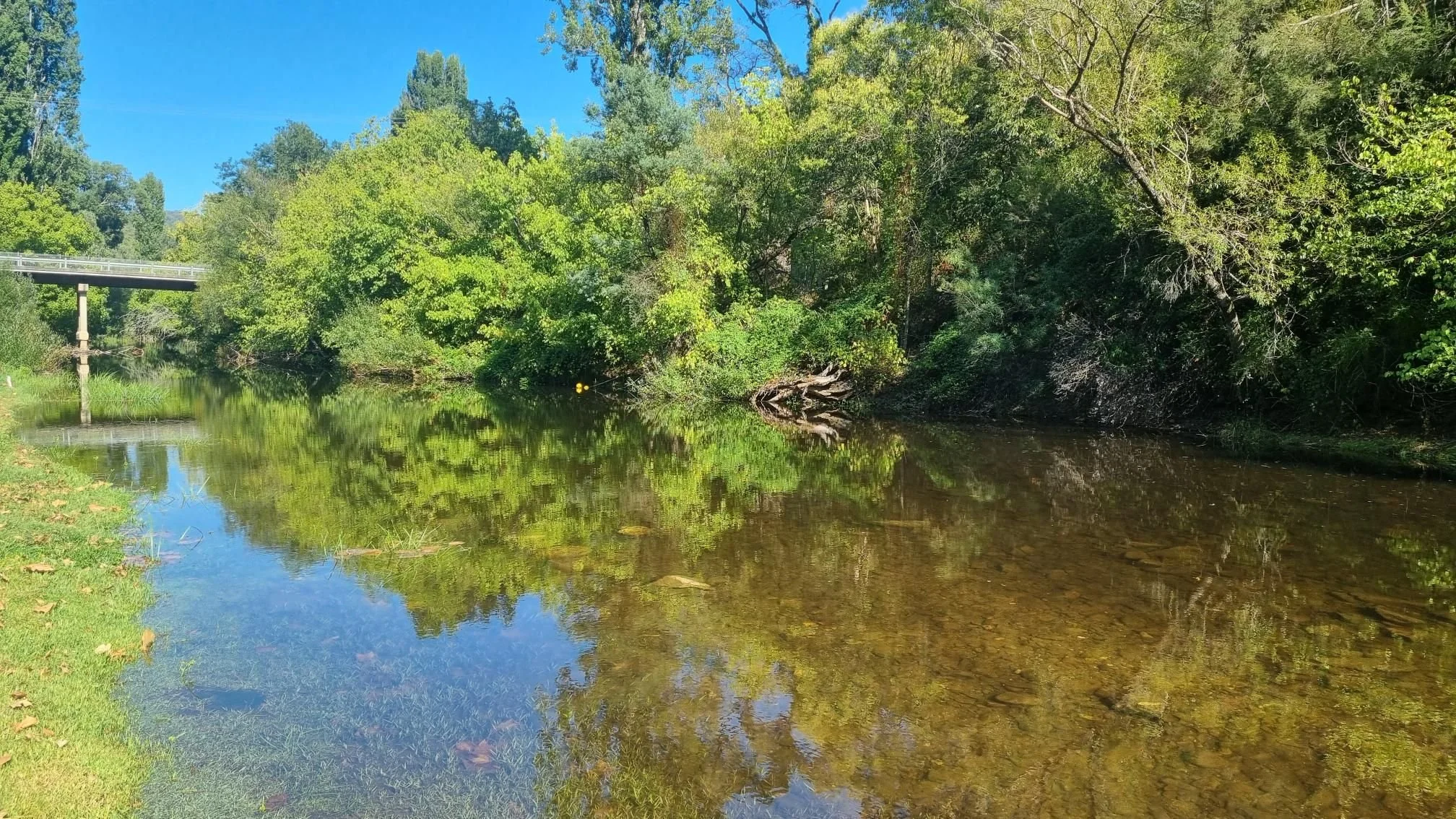
From the outset, you are in cattle grazing land, with rolling green pastures. The first 10km of the trail are sealed until the historic Nicholson River Bridge with its beautiful river views.
The trail then becomes well groomed gravel until your approach Bruthen, where you ride alongside the old Deep Creek Trestle Bridge. From here, you have a choice of two paths into Bruthen: the hillier, scenic route, or the direct roadside route straight to town.
You climb out of Bruthen, northbound on the remarkably quiet Omeo Highway. If it’s a hot day, you can cool off at Evan’s track swimming hole, six kilometres from Bruthen. Some climbing, followed by a long descent leads you to the beginning of a glorious, picturesque valley ride alongside the Tambo River. The Tambo will keep you company for the next 60 kilometres or so.
At Ensay, you leave the main road for the winding Ensay-Doctor’s Flat Road, and soon you’re at the Ensay Recreational Reserve Camping ground. Ensay-Doctor’s Flat Road sticks to the Tambo, but steers away from the Highway, with serene, rolling hills, and yet again a perfect surface, devoid of traffic. After 16 kilometres, you cross back over the Tambo and join Swifts Creek East Road into Swifts Creek. The campground at Swifts Creek is managed by the General store, just be there by closing time for the key and a hot shower awaits! Here you can camp on the peaceful Tambo riverbank.

Half of your donation goes directly to contributors for creating new ride guides just like this one (read more about how this works). The other half covers the costs of running the website, and what’s left is my wage for the work I put into it.
Note: the software I use to process donations insists on collecting email and postal addresses, and I can’t turn that off! I’m not interested in your personal information, so if you would rather keep that to yourself, just enter fake details.
Leaving Swifts Creek, you soon say goodbye to the Tambo. The landscape opens up, before a seven kilometre climb followed by a gradual drop into Omeo. Alternatively, if you’re pining for gravel, another option is the shorter but steeper Tongio Gap Road into Omeo (note: I haven’t ridden Tongio Gap Road, check before taking the plunge).
Omeo is your last major supply point for over 100km. The town size and historic buildings belie its small population, as it services a large area of East Gippsland and the High Country. It is home to the Cattleman's 100 mile mountain bike race, a mountain bike park and BMX pump track. “The Bike Race”, a local artist’s hilarious sculpture is a must-see.
The road north out of Omeo takes you to the Big River Valley and then the Glen Valley, with the traffic disappearing soon after leaving town on a short climb. Well known to riders of Bicycle Network’s Peaks Challenge ("3 Peaks"), this section of the Omeo Highway is road cycling paradise. As you wind your way north, you pass the infamous WTF corner. You will never tire of the mountain, valley and river views. You are spoilt for choice of campsites, with CRB, Anglers Rest, Jokers Flat and Big River Bridge all highly rated.
Important note: The push over the Alps after Big River Bridge is deceptively harder than the ride profile suggests, particularly with a loaded bike. There are no campsites for another 42 kilometres. If you push on here, you are committed. This includes two, long 5-6 km sections of climbing, with steep ramps of over 10% at times, and you reach a peak of 1345m above sea level at Christmas Creek. This is a true alpine climb, and you need to be prepared for any weather conditions. The reward is a gloriously scenic, flowing, twenty kilometre descent to my favourite campsite of the trip, Lightning Creek.
From Lightning Creek, it’s an easy, gentle downhill to Mitta Mitta, well known for its gravel cycling culture. The Mitta township is set on an incredibly beautiful river, and the general store/café is cyclist friendly.
Mitta marks the end of an epic Omeo Highway journey, as you head up Mitta North Road through flat, open farmland. A right turn into the gravel Bullhead Road leads you up a 4.5 kilometre climb towards Bullhead Gap. Early in the climb, as you enter the forest, you will come across a somewhat confusing junction, with the left option appearing to loop downhill, and the right option appearing closed. Keep right, heading uphill, and you soon reach the summit, with a four-way intersection. Follow Bullhead Road to your right, down the compact, gravel descent and you are soon in an open grassy valley, in cattle grazing country. Be mindful of cow pat “landmines” and of course, the animals.
Yabba Road accompanies the northern reaches of the Mitta River floodplain. You sit high up east of the river, traversing twenty kilometres of rolling hills, with again, almost no traffic to speak of. This leads you to the High Country Rail Trail, and sticking close by Lake Hume, the rail trail soon lands you in Tallangatta, the last major supply point before Wodonga.
If you’re staying in Tallangatta, the Lakelands Caravan Park is an ideal stopping point, with huge campsites and cooking/laundry facilities, though for me the sunset views over the Lake were worth the visit alone.
Soon out of Tallangatta, you are back on the rail trail, and over the photogenic Sandy Creek Bridge, with panoramic lake views in either direction. There is a 10 kilometre detour to the old Lake Hume Dam Wall and spillway, well worth the effort, and a ride onto the Dam Wall road places you briefly in New South Wales. On the return trip, you can check out the Bonegilla Migrant Experience museum, before rejoining the Rail trail.
As you cross the river flats, the trail takes you over a series of fun, low-level bridges and boardwalks on your approach to Wodonga. If military history interests you, visit the Bandiana Army Museum (take note of the entry requirements) just before Wodonga.
The bustle of Wodonga is a stark return to urban life, with the train station just north of the urban centre.
WHEN
Best done from spring through to autumn. Winter is very likely to see snow on the Alpine sections. Summer tends to be very hot north of the Alps, and whilst never truly remote, the fire risk can be extreme, so if travelling in summer, inform yourself of fire warnings and total fire ban days from the Vic Emergency website or the Vic Emergency app.
GETTING THERE
The V-line train network can take you and your bike to/from both Bairnsdale and Wodonga. The Bairnsdale line can be prone to service interruptions, though these tend to be planned well in advance (check here).
RESOURCES
OTHER RIDES LIKE THIS ONE


Disclaimer: should you choose to cycle this route, you do so at your own risk. Although all reasonable efforts have been made to ensure its accuracy at the time of writing, Adventure Cycling Victoria cannot guarantee that the information herein is 100% correct. The information published is meant as a guide only, and should be combined with your own due diligence and planning. Adventure Cycling Victoria and its contributors are in no way liable for personal injury, damage to personal property, or any other such situation that might happen to individuals following this route.

Where: East Gippsland, Tambo River Valley, High Country, Mitta Valley, Lake Hume, Bairnsdale, Omeo, Albury-Wodonga
Length: 345 km
Difficulty: moderate/hard
Terrain: varied – flat, rolling hills, gradual inclines/descents, short and long climbs/descents. Some steep climbing on sealed roads.
Surface: mostly sealed, with some well groomed gravel, and rail trails to start and finish. Any gravel bike would suit.
What: rail trails, rolling green hills, long river valley roads, alpine climbs, open grazing cattle country, lakeside riding. Picturesque views for days.